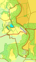
 This walk takes in a number of the most famous features on the North York Moors, starting with the fantastic view from the top of Sutton Bank, rated as one of the best in Yorkshire. It then passes by the White Horse of Kilburn, before heading down to the low ground.
Once there the path takes us along the foot of Sutton Bank, giving us great views of the bank from below. It then passes around Gormire Lake, the largest natural lake in the national park, before climbing back up onto the top of the bank to return to the Sutton Bank Visitors Centre.
Ascent: 1600ft/ 490m
Length: 8.5 miles/ 13.5km
Map: Explorer 26
Last Walked: 30 September 2006
Go to printable version
There are four possible starting points for this walk. I began at point 3, from the car park at the very bottom of the hill below the White Horse. However, that is a small isolated car park, and perhaps not the best place to leave a car on a quiet day. Here I had started at the Sutton Bank Visitor Centre, well worth a visit. It would also be possible to start at point 2, the car park at the top of the White Horse Bank. Finally, you could start at the car park immediatly below the White Horse.
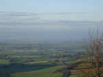 From the visitor centre head west to the top of Sutton Bank. Follow the path south as it runs along the top of the bank, first past the woods of Kilburn Moor Plantation, then past the Sutton Bank Gliding Club. This is one of the more dramatic viewpoints on the walk, passing around the top of Roulston Scar and above the White Horse of Kilburn. On a clear day it is possible to get a very good view across to the Yorkshire Dales from Sutton Bank. Further around the bank we get great views south across the Howardian Hills.
 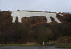 Just past the White Horse the path splits. One branch heads down hill to the left of the White Horse, while the other path continues along the ridge line. Follow the left hand (upper path) as it winds through the shrubland, curving around to the north before reaching a minor road close to a car park.
Turn right onto the road, and head towards the top of the bank. This road zig zagged down the side of the bank. At the start of of the first curve, a forest track leaves the road to the right. Leave the road and follow this forest track as it runs down the top of a ridge through the woods, with a steep drop off to the left (if you miss the first turn, it is possible to get onto the track where the road curves back to the left after the first steep drop).
Follow the forest track down for about a fifth of a mile. Ignore the first track leaving to the right. At the second turn it should be possible to glimpse the road through the trees. Take this track and return to the road. A public right of way is marked as passing through the trees just before the road. When I last walked this route the top of the path was not clear, but if it is turn onto it to cut off a corner of the road. Otherwise follow the road as it curves right then left, decending steeply towards a small car park close to the bottom of the hill.
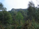 Follow the track as it curves to the right and enters the woods. Here the track runs between Roulston Scar, to the right, and Hood Hill to the left.
At the northern end of the woods, leave the track and follow the signposted footpath as it continues due north across the fields towards Hood Grange. The dramatic natural ampitheter to the right is known as Happy Valley,
 Just after the end of the second field, you will reach a crossroads in the foot path. Turn right and follow the path that heads towards the woods that surround Gormire Lake. Follow this path as it climbs up into the woods, then as it curves right and heads downhill towards the lake. Follow the path as it curves around the southern side of the lake.
 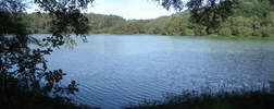 At the south east corner of the lake, turn left onto the path that follows the eastern edge of the lake. The official right of way runs a little to the each of the current path, which joins it just past the northern edge of the lake. Follow this path until it joins a track just before Southwoods Lodge
 The track dips down to cross over a small stream (Mire Beck), then gently rises again. Follow this track until you find a signposted footpath leaving to the right. This path passes just to the right of Southwoods Hall, and then climbs steeply up the front of the bank.
 After climbing up the open fields, the path reached the edge of a narrow band of trees close to the top of the bank. The Ordnance Survey map shows the right of way turning left into the trees, before climbing up to the top of the bank, and indeed some signs of this route can still be found, amongst them a rather ragged stile, but the path itself no longer exists.
Instead, enter the woods through the very obvious gate and follow the path that climbs up to the right. This path soon reaches a forestry track (marked on the OS maps), running left to right along along the bank. Turn right onto this track, then almost immedietly left onto a path that climbs up to the ridghline. The trees stop slightly before the top of the bank, so continue on upwards until you reach the Cleveland Way, running along the top of the bank.