 This walk starts and finishes on what might be the best preserved piece of Roman road in northern Europe. For the first mile of the walk, you will be on (or beside) what is probably the foundations of a Roman road, joining the Cawthorne Roman Camp and the fort at Lease Rigg (near Grosmont).
 After the Roman Road, the walk takes you around the upper reaches of Wheeldale, skimming the edge of the open moors to east and west. It also gives a chance to visit Nelly Ayre Foss, one of the less well known waterfalls in the area.
To reach the start of this walk from the south, drive north from Newton-on-Rawcliffe. Take the first turn right (down Rawcliffe Banks) Follow this road north. The road enters Cropton Forest after a mile and a half. For the final part of your drive, the forest is to your right, the open moor to the right. At the edge of the Forest, you will cross over Wheeldale Beck. Park here.
From the north, follow the road from Egton Bridge to Goathland. Just outside Egton Bridge the road turns sharply left and climbs sharply up hill. When the Goathland road turns left at Key Green, leave it on the minor road that continues to climb up the Hill. Follow this road for about five miles to the edge of Cropton Forest.
Ascent: 775 feet/ 230 meters
Length: 5 miles/ 8 km
Map: OS Explorer Map OL 27
Last Walked: 14 July 2006
Go to printable version
 From the bridge over Wheeldale Beck head up the hill north (away from the forest). You will find an information board and a gateway that leads on the the moor to the east. Just beyond the gate is the start of the probable Roman Road. You can either follow the path that runs along the right of the road, or walk along the road itself.
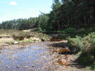
 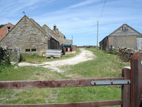 At the top of the climb, the path enters a farm yard (Hazel Head Farm). Follow the track straight ahead. This path soon leads onto a tarmac lane which we follow. From this part of the walk there are good views towards Goathland.
  As you come to the end of the last field wall, you will find a signpost labeled 'Foss', and a path that turns off to the right, heading down towards the valley bottom. This is the path to Nelly Ayre Foss. If you want to visit the waterfall, then follow this path. You will return up the same path after your visit. If you don't want to visit the waterfall, then ignore this turn and continue on along the path.
If you look at the OS map you will see a path marked here, following the field boundary towards the stream, and then turning right, down a bank, to the waterfall. Sadly, the second part of this path doesn't exist any more. Instead, the path turns left, following the edge of the woods down to the river bank above the foss. There is no easy way to get below the waterfall from here. On my last visit the stream was running very low, so I was able to use stepping stones in the stream to reach a rocky shelf that gives great views of the waterfall. If the water level is too high, or you simply don't want to risk getting wet, then it is possible to get a view of the foss from above. Instead of turning left down to the stream, turn right, following the field boundary. When you reach another wall, blocking your progress, the waterfall should be visible down the slope to your left.
It is possible to visit Mallyan Spout. When you reach the road at step 8, turn left instead of right. Just before the road crosses the stream, turn right onto a footpath. This path winds along the side of West Beck for about a mile, before reaching Mallyan Spout. Return the same way.
If you want to get out onto the tops, then it is possible to reach the top of Howl Moor. At step twelve, instead of turning down into the valley, follow the path that climbs slowly up the side of the moor, starting in a deep ditch. About a quarter of a mile later, a faint path crosses the main path. Expect this path when you are roughly level with the end of the fields in the valley bottom (look for a rocky patch on your left).. Turn left and climb to the top of the ridge to your left. If you are in the right place, then a much clearer path runs straight across the open moorland, to Simon Howe, clearly visible on the skyline. A line of cairns mark your route. Return the same way. The views from Simon Howe are worth the extra effort.