 This walk takes us into the Forge Valley, a steep sided wooded valley that was formed by glacial melt water, diverting the River Derwent from its original short route into the North Sea at Scarborough into a new route that eventually ends in the Humber.
Ascent: 365ft
Length: 1.75 miles (or longer)
Map: Ordnance Survey Explorer Map OL27
Last Walked:
Go to printable version
We start from the car park at Green Gate, at the western end of Low Road. If approaching from the south, take the right turn at the northern end of the valley.
 Cross this bridge, and head south along the valley for as long as you wish, remembering that we will be returning along the same route. When you are ready turn back and return to the east bank via the same bridge.
 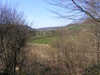 Just across the bridge a footpath heads off to the north (left) running along the narrow gap between the road and the river. Follow this path for as long as possible, but eventually, at the next car park, we are forced back onto the road for a short distance. Look out for the next footpath into the foods and follow this as it leads up to the northern edge of the woods. At this point the path leads off to the right, away from the Derwent, and climbs up to a now-closed car park and view point at Hazel Head (a clear raised bank). Use the original exit from the car park to reach the road north out of Forge Valley. Cross this road onto a footpath that cuts diagonally to the right through the trees to return to our starting point.