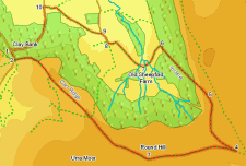
 This walk takes us from the very useful Clay Bank car park up to Round Hill, the highest point on the North York Moors (if not quite the best viewpoint). From Round Hill the walk continues on until it joins up with the Rosedale railway, before dropping down into Greenhow Botton on the incline once used to lower the output of the mines onto level ground for the journey to the outside world. This is a rather dramatic piece of engineering and even now is a steep path. We then cross Greenhow Botton, giving us an unusual close-up view of the northern escarpment of the moors, before climbing back up to Clay Bank.
Ascent: 1,100ft/ 340m
Length: 7 miles/ 11.5km
Map: Explorer 026 North York Moors West
Last Walked: 3 November 2006
Go to printable version
SWe start at the car park at the top of Clay Bank
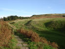 At the top of the pass turn left onto the Cleveland Way and follow it as it climbs up onto Carr Ridge, Urra Moor and eventually to Round Hill. This path is just about impossible to miss now, being virtually paved in large sections. If in doubt head uphill until there is no more up to go.
 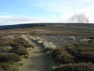 We are now at Round Hill, the highest point on the North York Moors. The top of the hill itself is slightly to the north of the Cleveland Way, so take a brief diversion to visit the summit. Sadly the top of Round Hill is a little too far from the northern escarpment to make a really good viewpoint in that direction, but the views to the west, south and east are impressive. From Round Hill return to the path and continue east along the Cleveland Way.
  Here we are going to leave the Cleveland Way. After passing Round Hill the path begins to lose height as it heads towards Bloworth Crossing. Just as the path begins to level out it reaches the branch of the Rosedale Railway that went down the incline. Turn left onto the old railway and follow it as it runs north towards the incline.
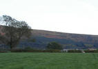
 The road north from New Sheepfold Farm curves left and then right. Towards the end of the curve right pass through a gate into the field to the left (signposted footpath). This path leads across four fields before reaching West Wood Farm. The path is very obvious in the first two fields - in the first field it cuts across the narrow southern tip of the field and then curves gently to the right. In the second field it cuts diagonally across to the opposite right hand corner.
 It is possible to get a little confused at this point (I did..). On the OS maps this second field is marked as being part of a bigger single field. Pass through the gate at the north western corner of this new field, and follow the path as it follows the left hand edge of this third field. This side of the field curves around to the right, following a small stream. The exit at the north west corner is hidden until we are quite close to it, but once it comes into sight is very obvious, and is well signposted as a footpath. Don't be tempted to pass through the gate in the western tip of the field - this leads into an odd shaped field that is a dead end.
Head diagonally across the next field, heading towards the middle of the western edge of the field, where a farm track enters the field. Follow the footpath west along this track and around the edge of West Wood Farm, following the signposts.