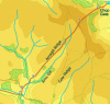
This is an unusual walk for me, starting and finishing at different places. This can be difficult to arrange (although during August the two ends of this walk are linked by a direct bus route), but is worthwhile, allowing us to cross a much wider expanse of the moors than normal.
This walk begins with a steep climb from Chop Gate onto Wether Hill, before crossing the top of a moorland ridge to descend along Arnsgill Ridge. We then cross the River Rye near its headwaters before climbing through one of the quietest valleys in the area. Finally we join the Cleveland Way and follow it into the popular village of Osmotherley.
Ascent: 1,605ft/ 490m
Length: 9 miles/ 14 km
Map: OS Explorer Map OL 26
Last Walked: August 2007
To printable version
This is a linear walk, designed to be followed in one direction from Chop Gate at its eastern end to Osmotherley to the west. If you don't have access to two cars or a friend willing to drop you off at Chop Gate, the Moorsbus route M9 travels between the two places, running on Sundays and during August (check the current timetable before you leave home). If you are using the bus, I recommend starting parking in Osmotherley and using the bus to reach Chop Gate.
 We start from the public car park just to the south of Chop Gate. Leave the car park over the bridge at its western edge (heading away from the road). We follow a track for a short distance before reaching a gate with a path and stile. Cross over the stile and follow the path, which splits off from the track, before crossing it after a short distance. This is a potentially tricky moment. The original path, as marked on the OS map, is now a ravine filled with gorse bushes. A track runs across our path at right angles. Turn right onto that track and then almost immediately turn left and climb directly up the hillside on the grass to the right of the original sunken path. Keep climbing, with the sunken path to our left. At one point there appears to be a choice between a path and a track, but the two routes rejoin after a short distance.
 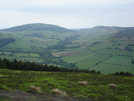 Having crossed two open fields we reach a stile, leading into a field to our left. Here we are going to leave the marked right of way and use an alternative path that is very clear on the ground. Instead of crossing over the first stile, continue up hill on this side of the field wall to a second stile. Cross over this style and follow the very obvious path as it climbs directly up the slope. This path curves gently around the northern side of this spur, with great views down into Raisdale before reaching a more gentle slope. Follow the still obvious path as it runs parallel to the marked right of way. Cock Howe is visible on the skyline and is our target.
 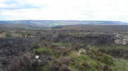 Our path passes to the left of a small plantation before reaching another Land Rover track. Join this track and continue on in the same direction (technically we turn right onto the track, but in effect we continue on in an almost straight line). The valley is now to our left as we walk along Arnsgill Ridge.
 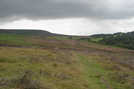 At the bottom of the hill, the road turns left, crosses the river and begins to climb. Leave the road here, and instead turn right through a gate onto another farm track. Follow this track for a short distance. Just after the track turns sharply to the left, leave it on a signposted footpath to the right, heading west along the left hand side of a field. This path continues through this field, before crossing over onto open moorland at the base of Black Hambleton (the hill dominating the view to our left).
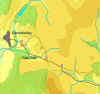
Follow this path across the heather. After just over half a mile the path dips down to cross over Bawderis Beck. Once over the back, the path climbs straight up towards an isolated cottage (currently being renovated). The path passes between the cottage and an older ruined cottage and then continues on through the heather. Follow this path until it reaches the Hawnby-Osmotherley road.
