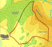
 This triangular walk takes us onto the top of Black Hambleton, the highest point and culminating point of the Hambleton Hills. On our way we use one of the wilder routes onto the Cleveland Way, and then follow that long distance path along the western edge of the Moors, along one of my favourite sections of the Way.
Ascent: 1,060
Length: 7.5 miles
Map:Ordnance Survey Explorer Map OL26
Last Walked:
Go to printable version
We start at the Forestry Commission Car Park in Burton's Plantation (head east from Nether Silton, turn left just outside the village then right onto Moor Lane, and follow this lane all the way to its end).
 A short distance after this left turn the road turns sharply back to the right. At this corner a lane leaves to the left - take this lane and follow it as it passes to the right of Nab Hill, a spur that sticks sharply out from the higher moors.
 We follow this track past Nab Farm and as it curves around to the right to cross the valley of Bridge Beck. Just beyond the beck the lane curves around to the right, while a smaller but still clear path heads off to the left, climbing up to the left of a small plantation. Turn left and follow this track as it climbs all the way up to the Cleveland Way, running across the top of the escarpment to the east.
 Turn left onto the Cleveland Way and follow it as it runs north across the western edge of Arden Great Moor and then north-west along Black Hambleton. Just before the path begins to drop down the northern end of Black Hambleton a track leads east across the heather to the trig point - follow this track up to the highest point on the hill before continuing on down the slope.
  Follow the path as it drops down past Hambleton End, with the open moor to the east and a forest to the left. Towards the bottom of this slope look out for a path that leads off into the trees to the left. Follow this path until it joins a forestry track, then turn left onto this track and follow it as it runs down hill back to the car park.