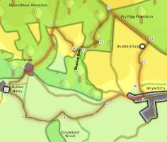
 This walk explores the south-western corner of the national park, starting in the village of Ampleforth, then visits Byland Abbey and the tiny village of Wass before climbing up the southern escarpment of the Moors to visit Shallow Dale and the prehistoric monument of Studfold Ring.
Ascent: 1,100ft
Length: 7 miles
Map: Ordnance Survey Explorer Map OL26
Last Walked: 18 April 2009
Go to Printable Version
There is roadside parking in the western half of Ampleforth village, in the vicinity of the fish and chip shop.
 We follow this road as it climbs up out of the village onto the flanks of Knoll Hill. After a short level patch we reach the top of Jerry Carr Bank, where we turn left onto a footpath that runs diagonally across three fields to reach a footbridge across Holbeck.
 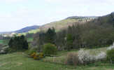 On the far side of the bridge follow the path that runs diagonally to the right across the next field, heading for the right (western) end of some woodland. This brings us to a field with a steep hill on the left and a barn to the right. Skirt around the edge of the hill, keeping the barn well to the right. At the top of the rise a small enclosed pond comes into sight. Head to the left of this pond, and then follow a farm track that runs along the left-hand edge of the next two fields.
 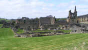 Cross the road and head up the drive of Abbey House. After a short distance turn right onto a signposted footpath that crosses a small field in front of the house and then emerges into a larger field, with a steep slope to the left. Follow the path as it runs diagonally across this field to the far left corner, where there is a very well placed bench. Cross over a stile behind the bench and then continue along the path as it curves around to the north and heads into Wass.
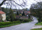
 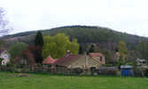 Our path brings us on onto a minor road at the western end of Wass. Turn right and follow this road to the crossroads in the centre of the village. At the crossroads turn left and follow a minor road that climbs up a steep wooded valley.
 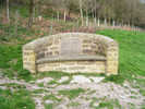 At the edge of this band of trees we emerge at the top of an open field, looking down on a farm house, and next to a well situated stone seat. Drop down the slope towards the farm house, and then turn left to head towards a track that comes into sight soon after passing the seat. Ignore the farm gate leading from this field onto the track and instead head for a small gate a little further to the north. Follow the track as it heads north away from the farm towards the top of Shallow Dale.
 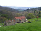 Follow the track as it curves gently around to the right and crosses the stream that runs through the dale. Watch for a footpath that leaves to the left at the point where the track turns sharply to the right. Turn onto this footpath and follow it as it enters a forest and climbs up alongside Drakendale Gill.
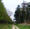 Our path brings us up to a forest track. Turn left onto this track and then follow it as it curves right around the hillside and then straightens up to head north through the forest.
 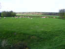 We stop on this road for about two thirds of the mile, most of the time with Pry Rigg Plantation to the left and open fields to the right. About half-way along this section of road walking we pass a band of trees around Studfold Farm, and the prehistoric
 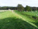 earthworks of Studfold Ring comes into sight. We continue along the road until we approach a second band of trees on the right. Just before the trees a signposted footpath leaves to the right, heading down a long but very narrow field. Half way down this field expands to include the Ring, which is well worth a careful look. After that continue down the field to the far end, where a stile leads into the next field. Follow a farm track that runs along the right hand side of this field, then turns sharply to the left.